Japan on Foot
Japan on foot reveals a quieter country, where walking between neighbourhoods, temples, and rural paths allows everyday rituals, landscapes, and human scale to shape the journey more than distance or speed.

Pilgrimage Trails, Old Roads, and Quiet Shrines
Japan has more pilgrimage routes than most countries have highways.
Some connect 88 temples across an entire island. Others lead to single mountain shrines accessible only on foot. Many were established over a thousand years ago by monks who understood something simple: spiritual transformation requires physical movement. Walking changes what you're capable of thinking.
What follows isn't a religious pilgrimage (though it can be, if you want). It's an introduction to Japan's landscape as architecture, where mountains, forests, and temples were arranged to produce specific psychological states in the people who walked between them.
Geography as spiritual technology.
Kumano Kodo: the old road to three shrines
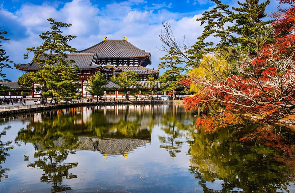
The Kumano Kodo is a network of pilgrimage routes on the Kii Peninsula that has been walked for over a thousand years. Three grand shrines, Kumano Hongu Taisha, Kumano Hayatama Taisha, and Kumano Nachi Taisha, form a triangle across mountainous terrain.
The routes are UNESCO World Heritage sites not simply because they're beautiful (though they are), but because they've maintained continuous spiritual use since the Heian period.
The most famous section runs from Takijiri-oji to Kumano Hongu Taisha: 38 kilometres through cedar forest and stone markers that have guided pilgrims for centuries. It's a serious walk.
If you want the essence without the endurance test, take a shorter section of the Nakahechi route, for example, Hosshinmon-oji to Hongu Taisha. You still pass oji shrines (subsidiary shrines marking progress), cross wooden bridges over mountain streams, and walk on original stone paving laid in the Edo period.
At Hongu Taisha, the atmosphere shifts. This isn't a museum. It's an active shrine where priests perform rituals that have held their shape for centuries. Unpainted wood. Gravel courtyards. Torii gates marking the boundary between ordinary and sacred.
From here, you can follow the old logic of travel and take the river.
A traditional boat ride down the Kumano River toward Shingu isn't just transport. Its transition, a slow return from mountain sanctity toward the coast.
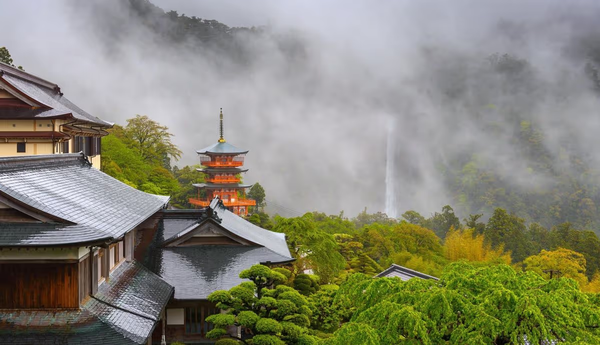
Nachi Falls: where nature became shrine
Nachi Falls drops 133 metres in a single unbroken cascade, Japan's tallest waterfall.
For over 1,400 years, it has been worshipped as a kami (deity). The waterfall isn't a symbol. It's the object of veneration.
The approach via Daimonzaka is deliberate: a stone staircase climbing through ancient cedar forest, steps worn smooth by centuries of pilgrims. The path is designed to tire you. Physical effort before encounter.
At the top, Kumano Nachi Taisha shrine and Seiganto-ji temple sit side by side, an arrangement that shows how Shinto and Buddhism coexisted (sometimes uneasily) for over a millennium.
The three-storey pagoda of Seiganto-ji frames the waterfall in the view everyone recognises. But the composition isn't accidental aesthetics. Its intention: pagoda, water, forest, arranged to create a specific visual and spiritual effect.
Go early if you can. Not for exclusivity, for silence. The roar of the falls lands differently when it isn't competing with human voices.
Shikoku Henro: walking 88 temples across an island
The Shikoku Henro is Japan's most famous pilgrimage: roughly 1,200 kilometres connecting 88 temples around Shikoku.
Kdbd Daishi (Kbkai), founder of Shingon Buddhism, was born on Shikoku in 774 CE. The route traces sites associated with his life and teachings.
Walking the full circuit takes 4560 days. Most people don't. But even a small section carries the logic of the whole: ritual movement, repetition, humility.
Traditionally, the Henro is divided into four stages, each representing a stage of spiritual development:
- Awakening (temples 123 in Tokushima)
- Discipline (2439 in Kochi)
- Enlightenment (4065 in Ehime)
- Nirvana (6688 in Kagawa)
Begin where pilgrims begin: Rydzen-ji (Temple 1). You'll see the white vests, the walking staff, the quiet etiquette. Even if you're not religious, you feel that this isn't hiking. It's a pattern of behaviour.
In Kochi, the Discipline stage includes some of the most physically demanding sections: steep climbs, long stone stairways, forest that closes in. The effort is intentional. It tests resolve and narrows the mind to what's directly in front of you.
And if you want a different narrative arc, walk a small section against the usual direction. It changes the psychology. The route becomes less about completion and more about attention.
Koyasan: mountain as monastery
Koyasan (Mount Kdya) is a mountain town that functions as a monastery.
Established by Kdbd Daishi in 816 CE, it is the headquarters of Shingon Buddhism and home to over a hundred temples. The entire mountain is treated as sacred space.
Arrival requires effort, a climb by road or cable car, and the town sits high enough that the air feels different. Cooler. Often misted.
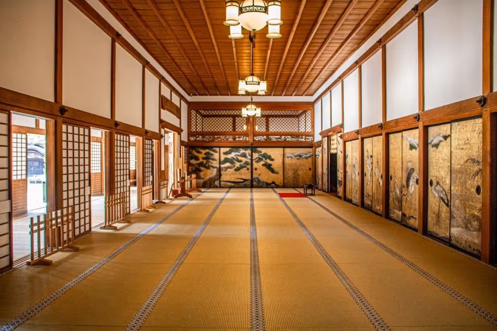
Stay in a shukubō (temple lodging) if you can. You sleep on tatami, eat shōjin ryōri (Buddhist vegetarian cuisine), and have the option to attend morning prayer. The ritual is simple but powerful: chanting in candlelit halls, incense rising toward beams darkened by centuries.
Then walk Okunoin Cemetery, a two-kilometre path through towering cedars, lined with over 200,000 graves. Feudal lords, monks, ordinary people who wanted to be near Kdbd Daishis mausoleum.
According to Shingon belief, Kdbd Daishi did not die. He entered eternal meditation in 835 CE and remains in his mausoleum, awaiting the future Buddha. Monks still bring him meals daily.
Whether you believe it is irrelevant.
What matters is understanding that for practitioners, this mountain is a living spiritual centre, not a historical site.
The old roads: when walking was infrastructure
Before railways, Japan was connected by footpaths.
The Tkaid (the Eastern Sea Road) linked Kyoto and Edo (Tokyo) along the Pacific coast. It took nearly two weeks on foot and included 53 post stations where travellers rested, changed horses, and passed through checkpoints.
Much of the original road has been paved over. But sections survive, and walking them produces an odd sensation. You're using infrastructure that was already old when Japan opened to the West.
The checkpoint system reveals something else: movement was regulated.
Officials inspected travel permits, enforcing a policy often summarised as outgoing women and incoming guns, designed to keep daimyo families effectively hostage in Edo, and to control weapons.
Not spiritual. Bureaucratic.
But it tells you how power worked.
Nakasendo: the mountain alternative
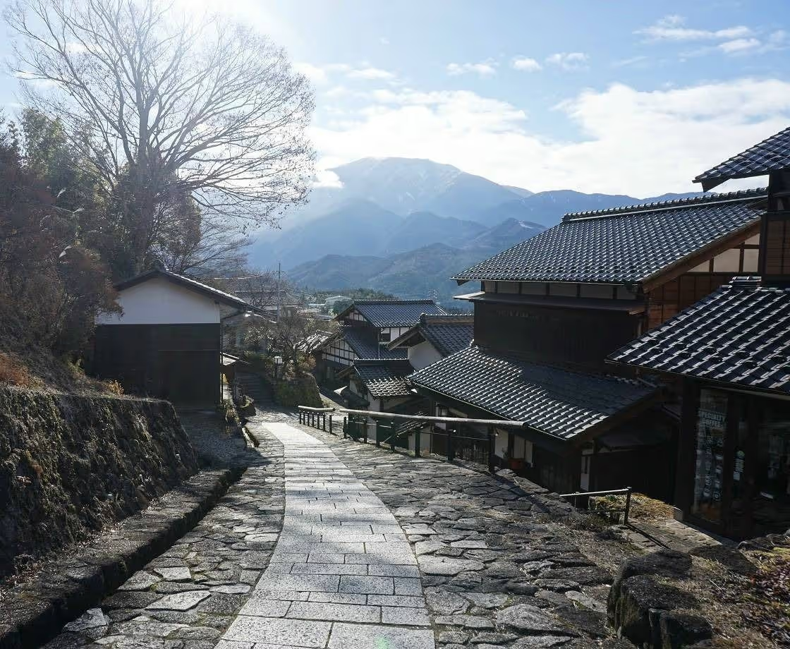
The Nakasend (the Central Mountain Road) was the inland alternative to the coastal Tkaid. Fewer travellers used it because the terrain was harder, which is exactly why sections remain intact.
The walk from Magome to Tsumago is one of Japan's most accessible historical trails: forested valleys, waterfalls, and post towns where Edo-period architecture has been preserved (and sometimes carefully restored).
Tsumago-juku looks nearly identical to 19th-century woodblock prints because the town adopted strict preservation ordinances in the late 1960s, banning modern construction materials and overhead power lines.
For something quieter, choose a less-travelled section such as the Torii Pass route toward Narai-juku, a long, linear post town shaped by geography, houses compressed into a narrow valley.
And if you want to connect walking to making, do a small craft workshop along the way, for example, carving hinoki (Japanese cypress) chopsticks. It's a reminder that craft emerges from material availability, not abstract design.
Why walking changes understanding
Japan's pilgrimage routes and old roads were not designed for tourism. They existed as infrastructure, ways to move between places when movement required effort.
Modern travel eliminates transition. You board a train in Tokyo and arrive in Kyoto a few hours later. The landscape becomes irrelevant.
Walking restores geography as experience.
You notice elevation changes, water sources, how forest composition shifts with altitude. You understand why certain temples were placed where they were, not arbitrarily, but because those locations had specific qualities.
These routes also reveal how Buddhism and Shinto coexisted for over a millennium.
Mountain shrines worship natural features as kami (deities). Buddhist temples occupy the same mountains, teaching that enlightenment requires transcending attachment to the physical world. The contradiction was never fully resolved. Instead, both traditions adapted, creating a religious landscape that feels distinctly Japanese precisely because it refused to choose.
You leave these paths with a different understanding of Japan.
Not just its cities and monuments, but its topology: how mountains dictated settlement patterns, how routes connected communities that would otherwise have remained isolated, how spiritual practices were shaped by the landscapes they occupied.
This understanding does not come from reading.
It comes from walking.
For customised pilgrimage and trekking routes in Japan:
manish@unhotel.in
.avif)
.avif)

Subscribe to stay inspired.
Stories, ideas, and slow journeys - from hidden villages to distant valleys, straight to your inbox.
.avif)